I went to a bend in the tracks to meet the inbound Grand Canyon Railway approaching Williams and caught this photo of the train approaching.

This is the tail-end of the train and I found out who this gentleman was talking to someone via radio (see next picture). There were security personnel approaching me from two directions, probably called in by the engineer and confirmed by this gentleman. Driving though a field to get this vantage point, I missed the signs identifying this area as an active switching yard and there were very large “No Trespassing” signs at the other entrance. Claiming stupidity works and I already had the shots I wanted.

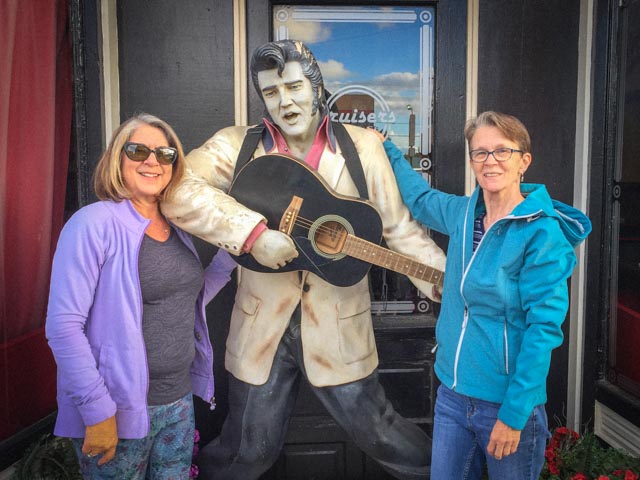
After Kathy and Mike arrive the next morning, we walked the downtown district, visited the local library where we picked up some books at .25 each, Kathy bought some too! We continued walking the street and ventured into several more stores. The C/Kathys were goofing around with an unidentified singer on the street. In broad daylight!
Everyone was starting to get hungry so we stopped at the Pine Country Restaurant for dinner, which was very good. Then it was just a short stroll back to the motor home, to rest for an early start in the morning. It was very convenient staying at the Grand Canyon Railroad RV park where everything was in walking distance.
We left Williams anticipating an easy, 220 mile drive to the North Rim, but, when approaching Cameron, we stopped at McAlister’s Deli so I could pick up a muffalleta sandwich for lunch. Well, both the road and deli were closed. The clerk informed us that there was NO short detour.
She sold us a Navajo & Hopi Nations map and routed out a bypass for us. Apparently, the road had developed a large, deep washout due to a flash flood. We backtracked to Flagstaff, then turned towards Leupp, Hotevilla and Tuba City before rejoining Highway 89, just a couple of miles beyond McAlister’s. This reroute resulted in an additional 450 (round trip) miles and took us through the Navajo & Hopi reservations. This was not a good start to the day.
We arrived at our cabin near the North Rim entrance to the Grand Canyon much later than anticipated but made time to enter the park, find the trailhead and have a dinner at a deli near the Grand Canyon Visitor Center. Black beans and rice, perfect for a cross-canyon trek! Then we walked over to the lodge and took a last look at the canyon. I was getting a little nervous. It looked deeper and wider than I remembered. We spotted numerous deer and several bison on the way back to the cabin.
Cathy drove us the 15 miles to the North Kaibab trailhead, arriving at 5:15 AM. The parking lot was already near full! Within minutes we were geared up and on the trail, eager to get moving to stave off the high 30s temperatures. We started in total darkness so Mike and I were both wearing headlamps. We showed a couple of hikers the trailhead, which was hard to spot in total darkness (it pays to scout out these things the day before). Cathy returned to the cabin to pick up Kathy and they begun their (detour added) eight-hour drive to the other side of the canyon.
We met and passed (and were passed) by several other, younger hiking teams also equipped with headlamps. It was a surreal view looking up at the cliffs we had just descended and seeing the headlamps of other hikers snaking their way down the very narrow trails. The sunrise was soon after 6:00 and light began to filter into the canyon fifteen minutes later. Soon after, we would turn off and stow our headlamps.
This is a view of the sunrise from the trail, just before the Supai Tunnel.

Getting down into the canyon required miles of these switchbacks, which at times were full of water, mule stuff, specially designed rocks for tripping and some very slippery surfaces.

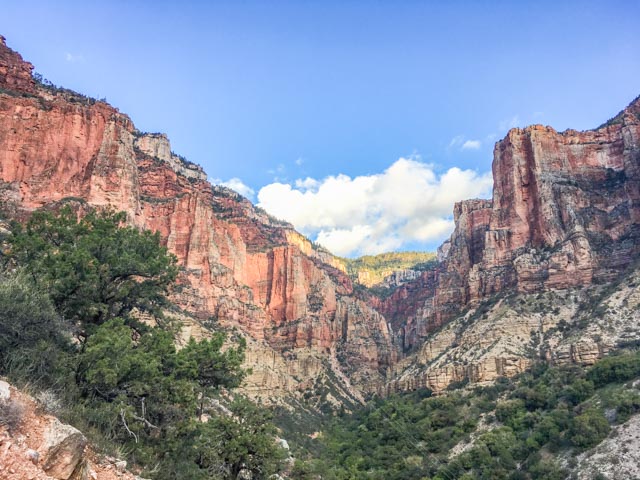
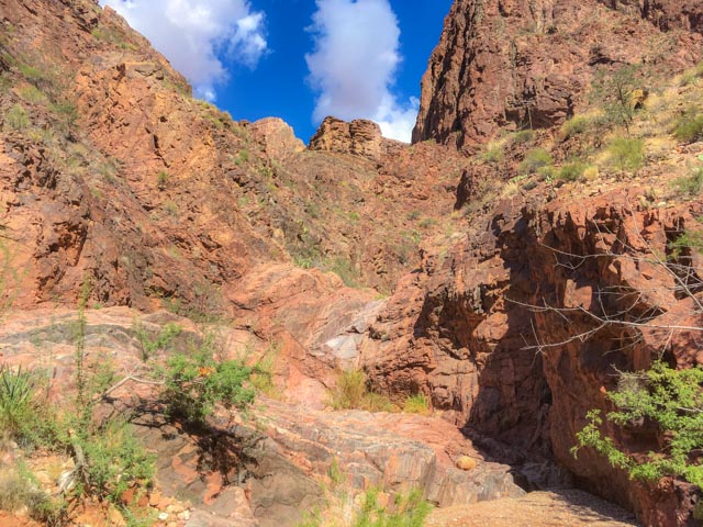
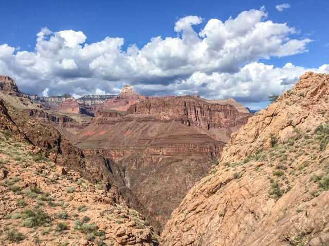
As we got deeper into the Roaring Springs Canyon, the views got increasingly more beautiful, too much to describe and pictures do not do it justice.

We had to document our first stream crossing at the Redwall Bridge, about three miles into the trek. There were to be many more as the trail zig-zagged down the canyon. I changed at this point into a short-sleeved shirt and Mike stowed his rain jacket, as the temperature was starting to build a little. At this point we had descended about 2,200 feet.
Here are a couple of views from the trail. On the shot of the red rock, Kathy later pointed out an eye like feature, located center top. Was it keeping an eye on us?
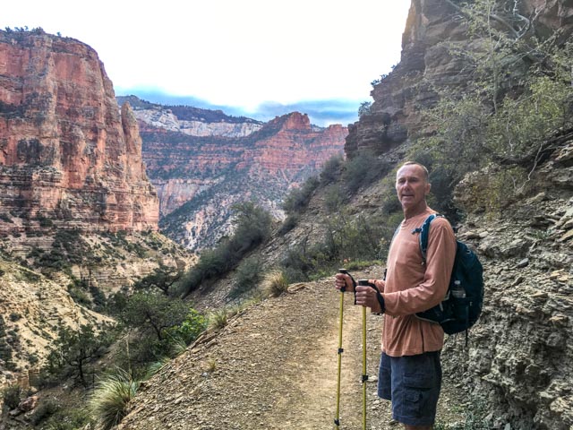
Mike is posing (and waiting for me) on the trail.
The sun was starting to hit the higher parts of the canyon by 6:30 or so, making for incredible views.
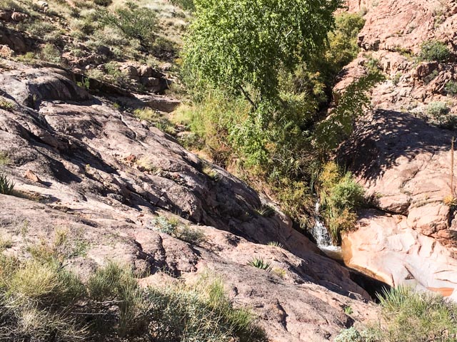
Here is a neat, man-made waterfall dropping into the Roaring Springs day use area at about the five-mile mark. Elevation here was 4,900 feet. The water system for hikers was disabled for repairs.

Another unnamed waterfall near the Manzanita Rest Area. Water was disabled here for repairs also.

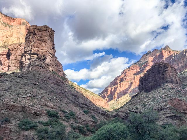
It is a beautiful view looking forward at our route down the canyon.

The sun is getting lower into the canyon. We had to relish this because we know that we will be in the “box” soon, with direct sun exposure for miles.
We made a one mile (round trip) detour to see Ribbon Falls at the eight mile mark, just past the Cottonwood Rest Area. The trail to the base of the falls had been washed out so I took the high road, climbing over rocks, but it dead-ended. Mike bushwhacked through the brush and made it to the other side, so I followed him and we made it to the base. This was an incredible sight in the middle of the small canyon. A couple of youngsters were enjoying the falls.

After leaving the falls, and the very steep climb back to the trail, we started into a section of Bright Angel Canyon, known by hikers as ‘The Box’, which is exposed to direct sunlight, can get scorching hot and is dreaded by the hikers. Most try to get through this area before the heat of the day. Yes, we finally were in the sun but we managed to get through it early enough to beat the full effects of the heat.

The trail began winding down the canyon, following a creek.

Here is the view up a side canyon off the box.
Following the creek down the canyon, the views continued to improve, but where was that Colorado River?
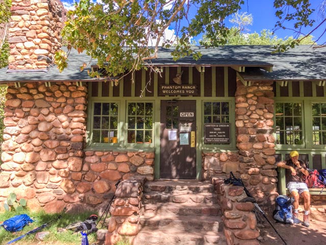
We stopped for “lunch” at Phantom Ranch, 16.5 miles into the hike. You can ride a mule down to this spot, camp in air-conditioned cabins and eat at a reservations only restaurant. We stayed outside and Mike had his jerky and other fine foods and I had a small bag of Cheerios and a Cliff Bar. We were high style eating at the ranch! This was the first water stop in over ten miles. We filled up for the eventual climb out, which we knew we had to do. It was still a mile or so to the river.
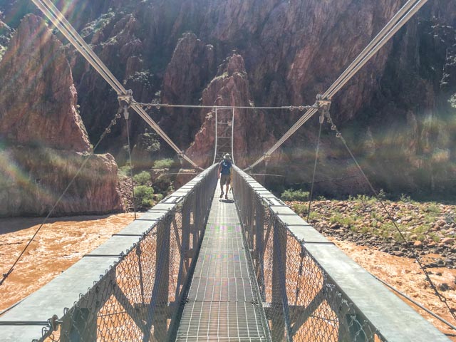
There are four bridge crossings located within the park. The Silver Bridge is a suspension design, used for the Bright Angel Trail and the nearby Black Bridge, located about a half mile upstream is for the South Kaibab trail. Are they color coded for delirious hikers?
Communications are scant here so Mike is communicating to his mom that he is still upright and alright.

Crossing the bridge was amazing. The bridge was very stable and the view upstream and downstream of the silt-filled, roaring Colorado were one of a kind.
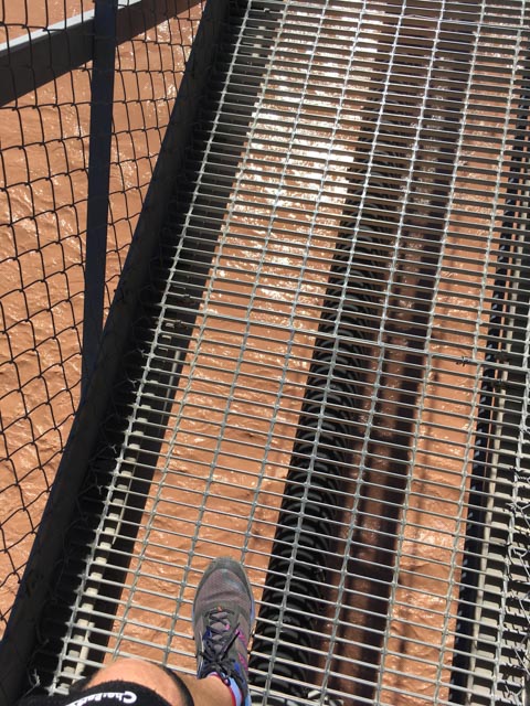
This was an oops shot. All of the photographs were taken with my telephone. I did not want to lug my “real” camera up and down the canyon. I included it because it shows the surface of this bridge and the river swirling below.
Looking upstream you can see the Silver Bridge in the foreground and Black Bridge upstream leading to the shorter North Kaibab Trail.

We hiked the River Trail, which consisted of exposed sand dunes for over a mile. It is considered a flat trek, but we climbed up about 800 feet then it cruelly dropped us back to river level before turning into Pipe Creek Canyon and the Bright Angel Trail. We watched these rafters, followed by two kayakers grouping up for a series of rapids downriver.
Pipe Creek was flowing low, but clear. This is where it dumps into the Colorado and there really is a small beach for swimming in the creek (not the river) here. As the sign says, we are just above the river at 2400 feet. To my back is the beginning of a 11.5 mile uphill climb.

We are now heading up the canyon, in the early afternoon, in the sunlight. You can barely make out the switchbacks in the face of the rocks above us. The majority of the elevation gain on this trail takes place in the last four miles via a series of switchbacks which seem endless.

Once we reached the top of the first series of switchbacks, I looked back at the trail. It is just to the right of the trees below (bright green in the bottom center) of the photo. We have climbed about three miles at this point, gaining about 2,000 feet in elevation. This section of the trail is known as the Devil’s Corkscrew.

Below is a view looking up towards Indian Garden. I didn’t think I would ever make it there and it was only the half way mark up to the trailhead on top. The switchbacks seemed to go on forever.

Another unnamed waterfall appeared on the uphill climb. This is Pipe Creek.
As we continue to climb, see the view looking back, with the sunlight continuing to inspire.
Indian Garden is an oasis in the canyon used by Native Americans up to modern times. Ralph Cameron, one of the early pioneers who built the Bright Angel Trail (and who would later become an Arizona senator) had come to an agreement with the resident Havasupai allowing him to build a camp for tourists. He staked mining claims to secure the site, built tent cabins, and planted the enormous cottonwood trees still present today. We stopped for a quick drink of water as time was ticking and we still had miles to the top.
While leaving the garden, we looked back and saw this sign. Maybe if we read this before the hike. . . . naw, not us!
My telephone ran out of battery and this was to be my last photo. Devine intervention?
After leaving the Garden, we crossed the shaley and desolate Tonto Platform. The platform looks flat from the trailhead at the top but in reality, it was brushy, full of large undulations and we did not even realize that we crossed it.
I was warned by a hiker I met a couple of miles downhill that the trail that after the Garden the trail was very steep and composed of long switchbacks. . Whoopie!
He was right.
Somewhere, far up the series of endless switchbacks we looked down and realized that we actually had crossed over the Tonto Platform but failed to recognize it.
I was almost out of water when I reached the 3-Mile Resthouse and refilled my bottles and hydration pack. After taking a water break, I fell in behind several East Indian hikers. They were enjoying themselves, and were in relatively good shape so I continued with them to the top. At one point, when they (we) took a breather stop, one young lady asked me where I started, and they were shocked when I told them the North Rim. They were coming up from Indian Garden. Next stop would be the 1.5 Mile Resthouse and I refilled to capacity again. The final mile was a continuous series of switchbacks. It was becoming disheartening to see nothing but these switchbacks and hikers climbing up, up and up.
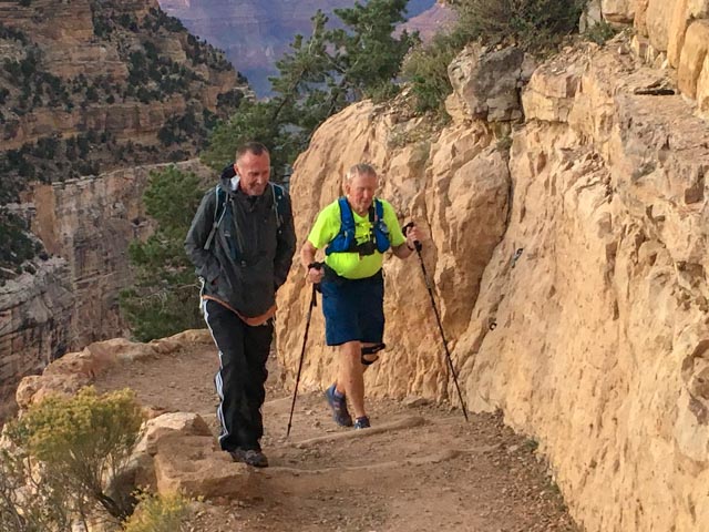
Cathy took this shot, from the Bright Angel Trailhead viewing platform, as I was exiting the Lower Tunnel about a mile below the finish.

I finally reached the final steps, just below the Bright Angel Trailhead viewing platform. Yes, I was too pooped to pop at this point and still had the 60+ mile drive back to Williams. Mike came down to walk the ol’ man to the finish area. He had finished well ahead of me and was still ambulatory. Notice that Mike had his “cold gear” on as it was getting a little chilly at the top and he had been there a while waiting for me.
28+ miles, 12+ hours and DONE.
Once at the top, a young hiker who I walked with on and off recognized me and asked if I could take a photo of him at the trailhead sign. I was pretty sore so I volunteered Mike to be the photographer as he was still spry. There were two in his group and I asked about the other hiker. He told me he cramped up at the tunnel, incapacitated and receiving help. It can happen to anyone as these two were in pretty good shape and had flown in from Europe specifically for this hike.
Epilogue
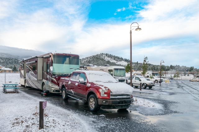
It got a little cold last night. We awoke to about 1″ of snowfall. I am glad we did our hike when we did as I assume the trail is pretty slushy as the trailheads are about 2,000 feet higher than our camp. Afterall, what would the Grand Canyon be without a little snow to brighten things up?
Some thoughts the day after:
- The official distance for this hike is 22.1 miles. We quickly found that to be inaccurate. Our trip was a little over 28 miles, which included the one mile off-trail to Ribbon Falls. I confirmed the distances with many of the hikers. Evidently the distances were determined years before GPS accuracy.
- The views were spectacular, which can only be experienced by the fortunate few who can make the hike.
- The experience was almost gruelling (at 12+ hours), but very rewarding. I met a lot of hikers and runners and thoroughly enjoyed the scenery, the camaraderie and the possibly once-in-a-lifetime experience.
- We enjoyed our several days visiting with Kathy and Mike Owen, hiking with Mike and support from Kathy. We are fortunate to have found them to renew our friendship.

Glad you made this back o.k. and can cross it off your bucket list! Good job! This one had me worried!
LikeLike
This was an ordeal. I am glad we are waiting a day before heading home. But . . I am glad to be able to have done it. Thanks
LikeLike
It was really nice to see Steve and Cathy again after so many years.
And it was my pleasure to accompany Steve on this hike. I’m glad we did it.
It was a great experience and worth all the effort.
Run safe in NYC buddy. We’ll be thinking about you guys.
LikeLike
We really enjoyed seeing Cathy and Steve again.
And it was my pleasure to accompany Steve on this hike.
The experience was great and definitely worth the effort.
Run safe in NYC buddy. We’ll be thinking about you guys.
LikeLike
I am so proud of you brother! What a great accomplishment and the pictures and narrative by Steve made us feel like we were there with you. I hope you sent to Mom as I know she will thoroughly enjoy seeing these pictures. Good job Mike!
LikeLike