Friday
On Thursday, I picked up my race bib for Saturday’s Pikes Peak Ascent, leaving Friday open for us. We drove into Woodland Hills and attended an outdoor gem and mineral show which had everything from fossils to very expensive jewelery. After spending a couple of hours walking the booths, we headed back to the Pikes Peak Highway and up the hill.

This was our first view of the peak, as seen from the highway around Crystal Reservoir. The peak is about 19 miles away at this point.

As we approached the summit, the trees disappeared; treeline is about 11,500 feet here.

There were some rather deep drop-offs alongside the highway. Cathy could not look down. You can see Manitou Springs in the far upper left of this shot. The sky continued to be hazy from the California wildfires, limiting the remarkable vistas.

I did find the U.S. Geological Survey marker at the “official” top of the mountain after I was told by two workers that it did not exist.

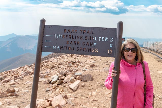
Cathy and I posed at the start/end of the Barr trail, with Manitou Springs 13 miles away. Our starting area had us at the other end of town so we would be running through the town to gain the necessary mileage.

We met Segev Jacob Appelbaum, from Ra’anana, a runner who traveled from Israel to participate in this event. He was sponsored by Team Salomon, a running and apparel company. He offered some tips on how to run this race, having participated in numerous mountain races in Europe (but never at the altitude of the Pikes Peak run).

On the way back down the hill, we were stopped at a mandatory brake temperature checkpoint, about midway down. Since I was using my gears as directed, my brakes had not heated to the point that I was “sidelined”.
Ps: I followed an elderly couple down the hill Monday, who were obviously afraid to drive in mountains with cliffs and no guard rails, thus kept their foot on the brake all the way down. They were sidelined at this mandatory checkpoint!

Saturday
On Saturday, we left for downtown Manitou and the race start while it was still dark, about 5 a.m. We met Segev again and he informed us of the race course change, due to high winds, with hail/snow on the summit, and gave me some hints on how to run downhill, something I was not prepared for. The mountaintop was closed to all visitors for the morning.
For the prerace anthem, they had a singer perform “America the Beautiful”, which was actually written on top of Pikes Peak! The 1,800+ runners were assembled into the proper chutes and the race began. We would be running to Barr Camp, at 10,200 feet and 7.7 miles up the mountain, then back down. Our start was at the Manitou Town Hall at 6,300 feet. The half marathon ascent had turned into a 7.7 uphill and 7 mile downhill run, almost 15 miles! I hate downhills, especially running on the rocks/boulders. The weather was bad the previous night, with gigantic hail damaging trees, flooding the creeks and damaging several motor homes in our park. We brought in our slides minimizing our damage to one docking light, which is mounted on the side of the motor home.
This was at the starting line, and I was still ready to go.

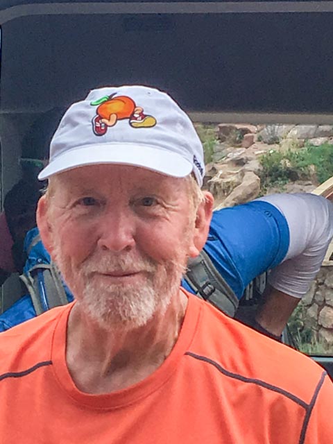
After the run, Cathy took this photo as I was getting out of the shuttle van that picked us up at the finish and drove us through town. I was just happy to have finished this ordeal.
Now, for the mandatory pose with my Pikes Peak Ascent medal, in front of the beer tent with a guy in the background that stared at his beer for several minutes. We met runners from Mexico, Spain, Israel, Norway, Switzerland, France, Japan and several African nations.

We drove into nearby old town Colorado City seeking a Chinese Restaurant that Cathy found on GPS. After finally locating the very small restaurant, we found parking and walked to it. It was a “Tea House”, not a restaurant. We went to plan “B” as I was too tired from the day’s activities to continue walking in search of another restaurant, and picked up frozen Chinese from the local supermarket and went back to the motor home for dinner. Actually, the frozen kind was pretty good!
Sunday
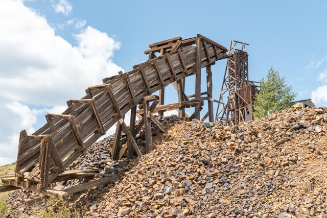
We decided to drive to Goldfield on Sunday. Going over the pass into Cripple Creek there was snow on the ground from the previous day, and this was thousands of feet below the Pikes Peak summit! We stopped at the visitor center just before entering the townsite of Cripple Creek. This visitor center was full of mining artifacts and we spent more than an hour going through all of the displays, it was well worth the time. As we entered town, it was immediately obvious that there was something going on. The roads were closed and there were motorcycles everywhere. We parked behind a casino and walked through it to reach the main street. The front of the Gold Mining Stock Exchange in Cripple Creek is pictured below.

Motorcycles lined both sides of the street. There were many “Harley” orientated booths with the associated paraphernalia. We were impressed by this dog training to be a guide/support animal. She was very disciplined and stood there like a statue (unless there was food on the grill at the next booth). There were Native-American dancers, aircraft flyovers, a parade, and a memorial in the city park was dedicated to our American Veterans.
This bike was put in its trailer as soon as there was a hint of rain. It was built for the Newmont Mining Company by Paul Jr. Designs of American Chopper. This bike incorporated mining parts and is partially gold-plated. It was built in 2012. It was stunning. There was a gentleman from Newmont there to talk with and we quickly discovered he was not a biker, but the head geo-engineer for Newmont. Boy, did he know his stuff! He told us about the mine, and gave us directions to various other mines in the area.

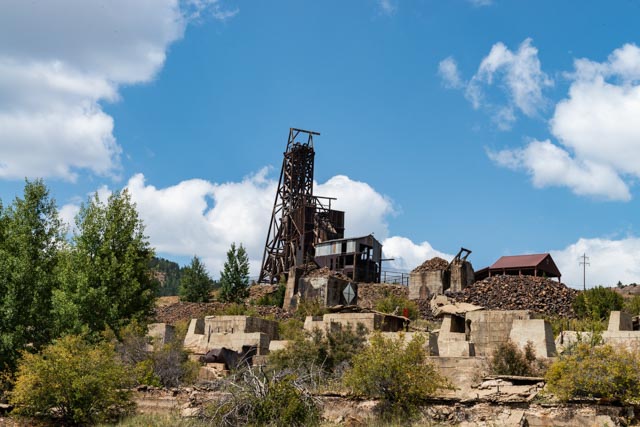
This is an unnamed mine shaft and buildings that we saw while driving the country road that was recommended by the engineer.

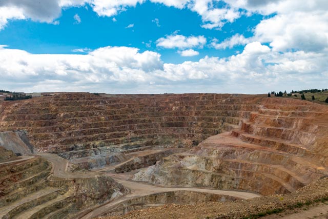
This is the Cripple Creek and Victor gold mine, owned and operated by Newmont. This mine yields about 451,000 ounces of gold yearly and employs about 600 workers.

Here is Cathy descending from the bed of a mining dump truck. Newmont has built an overlook into the mine using this truck bed as a viewing platform. We were told by one of the employees that this was a small truck bed compared to what they are now using in this open-pit mine.

Continuing on down this little-traveled road, we entered the town of Goldfield. Goldfield and Victor were the towns that the workers lived and worked in during the gold rush and Cripple Creek is where they spent their earnings. The actual mines were mostly located in and around Goldfield and Victor. This is about the only decent building that is still standing in Goldfield.

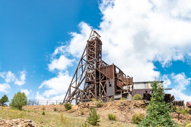
This is the Independence Mine, with the Independence Mill located directly below. I actually climbed a trail up from the paved road, through a barbed-wire fence and through the concrete foundations of the mill trying to get a closer look at the mine. I crawled through a second barbed-wire fence (which was obviously designed to keep cattle in) and upon reaching the top, found that there a was a dirt road leading directly to the mine! I did happen upon the quarters of a homeless gentleman in his tent living in the foundation of the mill.

I decided to avoid the excitement of squeezing through the barbed-wire fencing and passing the homeless person and decided to walk the newly found dirt road into the town of Victor. I could then turn back to where our truck was parked near Goldfield. Since they are only a couple of miles apart this would be the simpler route.
Walking the dirt road towards the town of Victor I passed by this abandoned loading chute. I could imagine the ore tumbling down this into awaiting wagons or ore cars.
Here is a closed, roadside view of the Independence mineshaft. This mine was sold in 1899 for $11,000,000 and produced in excess of $60,000,000 in gold, at 1899 prices! It descended to a depth of 3,300 feet.
There was another loading structure, located roadside. It is amazing how these structures have withstood the extremes in weather for more than a hundred years!

This apparently is an elevated ore car track used to discard mine tailings.

I passed the remains of the Strong Mine entering the town of Victor.

We drove the neighborhood of Victor, and high above the town, on the uppermost road we came across two fawns and two does, lunching alongside the road. They did not appear to be too afraid of us. You can see some of the town below us.
Monday
I decided sometime during the day to go back to Pikes Peak and “finish the drill” as coach Mark Richt used to say. Since the ascent route was altered due to weather, I would now go to the top and head down to Barr Camp (about six miles) then turn and head back up to the top. This would make my total mileage for Pikes Peak 27 miles. This way, I would have run down the entire mountain and run up the entire mountain! Since I did not carry a camera on Saturday’s run (due to the potential for crummy weather) I would carry one this time.
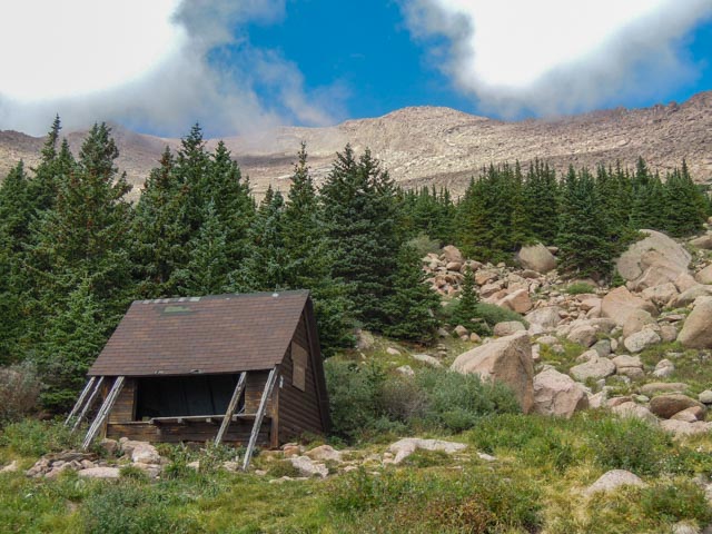
I started off my run on Sunday as soon as the park opened. Coming back up the mountain from Barr Camp, I passed the Timberline Shelter, aka the A Frame. This shelter is located right at the timberline, at an elevation of 11,950 feet. I walked down to the shelter then straight across trying to reach the edge of the canyon. After about a quarter of a mile, I turned back, as being off trail I would have been hard to find if something happened. There were sleeping bags and camp stoves in the cabin, so the occupants were somewhere up or down the hill. There was a nearby spring and flowing water just to the right of the structure.
Back on trail, and leaving the treeline, I took this shot heading uphill. The “trail” is very similar to others I have encountered on the 14ers, pretty rocky to say the least.

I took a couple more photos looking uphill from the trail. Since the clouds were swirling off the mountaintop, I took photos when I had some blue in the sky. In the second photo, Pikes Peak is the center “hump”.


Looking back towards Timberline, this is the memorial plaque for G. Inestine Roberts who died here on her 14th climb up the mountain.

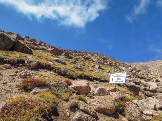
This is a mile marker left over from the ascent and marathon last weekend. Only two miles to the summit! Just stay on the trail.

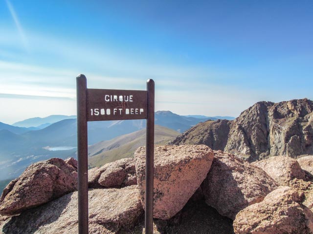
They say in the race instructions that, upon reaching the cirque, you may feel like taking the easy way out and turning left instead of right. Now I know what that means. A left turn will lead to a 1,500 foot sheer cliff.
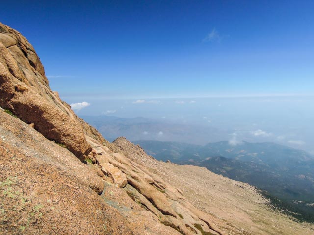
Looking over the cliff, it looks close, but those are trees down there!

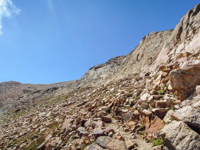
Only one mile to go to the summit! Just stay on the trail, kind of anyway. This climb is actually a lot steeper than it looks.
I went off trail again to visit this spring. It was hard to capture the water flow but it came out from under a rock, then crossed over to a hollowed-out flat rock making a natural bird bath. There were birds in it when I passed it earlier in the morning and birds in it while going back uphill. I missed the rock completely as my vision was not entirely there!

You may be able to see the trail hugging this side of this rockfall. It is about one foot wide and a misstep can give you one heck of a ride down the mountain.
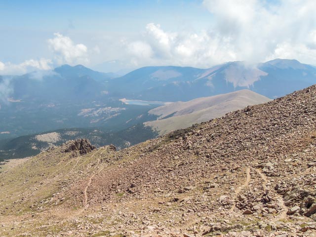
I took a photo like this a couple of days ago and now I actually know where the trail leads. Where the trail heads out to in the left third of this photo is the cirque and the 1,500 foot cliff. The trail on the right is leading to the “16 Golden Stairs”, the final push to the top. The 16 stairs actually encompass almost a half mile in distance and 900 feet vertical.
Almost at the top you come across this memorial to Fred Barr, the builder of the Barr Trail. This marble plaque is located high up on a rock overlooking the trail, about three-quarters of a mile below the summit.

I finished the run by 1:00 in the afternoon. After taking a few minutes to eat a sandwich and drink some fluids, I enjoyed people-watching. It is amazing to see families get out of their car, put on hiking boots, gather hiking poles, put on jackets, earmuffs, hats, scarves and walk to the edge to look down and say, “whow”! Then they took off all of the above and drove back down the mountain. It kind of reminded me of a scene from Chevy Chase’s “Vacation”.
I did meet several runners whom I ran with Saturday doing the same thing I was doing, making sure they could say they really did it! There was a gentleman from North Carolina who had a plane to catch that evening, a trio from Spain who were mapping out their run strategy for next year and a local couple who just wanted to finish the portion they missed on Saturday.
Final 14’r Count:
- Mount Evans 14,264 feet
- Quandary Peak 14,265 feet
- Mount Sherman 14,043 feet
- Mount Massive 14,421 feet
- Pikes Peak 14,115 feet

Beautiful
Sent from Yahoo Mail for iPhone
LikeLike
Thanks, because Pikes Peak stands basically alone in the range, it totally dominates the skyline . . . .We did not even touch on the Garden of the Gods, which is like a minature Sedona, right in town!
LikeLike