Today, Monday, August 13 is designed to be a rest day. My legs are still throbbing from Mount Massive yesterday! We drove into Leadville for breakfast at a place we scouted out the previous several days, The Golden Burro. This restaurant is said to be the longest continually operating restaurant in Lake County. It was moved to the present location on Harrison Street (the main street through town) in 1942. It is open only for breakfast and lunch. We chose the breakfast and Cathy had a build it yourself omelette and I had chicken fried steak and eggs. I almost went for the chorizo though! The food was great and the restaurant itself is filled with Leadville memorabilia from times past.
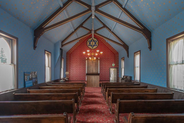
We drove to Temple Israel (from information furnished at the restaurant) and visited the “highest synagogue in the nation” (in elevation). This synagogue is the only building of its kind west of the Mississippi River, both as a restored pioneer synagogue and as a home to a permanent museum exhibition documenting an oft-overlooked piece of U.S. history. It was built in 1884 on land donated by Horace Tabor. David May, of May’s Department Store fame, later to become Macy’s, attended services here. The building has been fully restored and is filled (the back half only, as the front is still used periodically for services) with over 80 Jewish objects. Of special note to me was a display of about ten stoneware jugs from various Jewish merchants, with Leadville predominately displayed on the sides, a labeled whiskey bottle and an embossed decanter.

Our next stop was the Hebrew Cemetery, located within the Evergreen Cemetery where Cathy walked through some of the memorials looking for possible relatives.
Meanwhile, I found this interesting gravesite. J.B. Omohundro (aka “Texas Jack”) was a scout for General J.E.B. Stuart’s Confederate Cavalry during the war. He came west after the war, at the age of 19, where he made a name for himself as both a U.S. Army scout and a plainsman. He joined the Pawnee Indians on their summer hunt and was a wilderness guide for Britain’s Earl of Dunraven. In 1872 he co-founded America’s first Wild West show with friend Bill Cody. In 1880, he joined Horace Tabor’s Light Cavalry, a local militia formed to keep order in the newly formed town. He died from pneumonia at the age of 33. Several years later, Cody had this headstone placed to honor his friend (his age was mis-engraved at 39 years).

On a side note: Jefferson Randolph “Soapy” Smith of Skagway, Alaska fame visited the streets of Leadville in the late 1870s looking for unwary minors and travelers with pockets of gold from which he could swindle. Interesting fella, Soapy was. He was born in Coweta County, Georgia! Other notables tied to Leadville include the Guggenheims, “Bat” Masterson, “Doc” Holliday (born in Griffin, Georgia) and the Unsinkable Molly Brown.
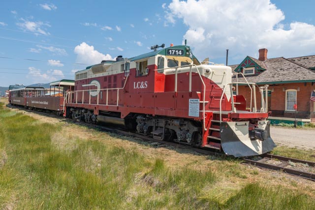
We heard the train whistle while we were downtown so we headed for the depot. This is the eight car Leadville, Colorado and Southern train at the depot on 7th and Hazel Street. It makes short sightseeing trips to the nearby mountains in both open air and glass enclosed cars.
We visited the mining district, traveling up East 7th to Evans Gulch, passing the Matchless Mine, the Denver City, the Evansville, the Silver Spoon, the Dolly B, the Resurrection No. 2 and turning around at the Diamond Mine. There were several of these routes through the hills surrounding Leadville. We stopped at the Mineral Belt Trail, a walking/bicycle trail built on an abandoned railroad bed, including some neat overhead trestles. I made a neat find at the Evansville mine in Lee Basin on the way back.
On the way back to the motor home just north of Buena Vista, we stopped at a small town called Granite, population 116. It required crossing a low capacity bridge over the Arkansas river (we could not have taken the motor home there). The town was founded during the 1859 Pikes Peak gold rush and quickly grew to 3,000 persons, including prospector Horace Tabor. Today’s Granite is just a ghost of what it was.
Once in town, and going up and back down the only street in town, we headed up a steep hill to see where the “road” led us. There were many signs that we were on a public road passing over private lands. Do not leave the road! On the steepest part of the drive we noticed a 40 gallon bin of sand at the bottom and at the top of the hill, I guess for slippery conditions. We traveled several miles (in 4 wheel-drive) and turned around when we found ourselves totally off the grid.
We returned to the motor home to get some drinks and headed to Buena Vista, about seven miles south of us. We walked the streets of this quaint town, through a bakery, a couple of sporting goods shops, an antique store and a vintage clothing shop, then on to the courthouse (which has been converted to a museum) before just driving around to see the area. We came upon a new development (somewhat similar in configuration to downtown Suwanee) and saw an event going on. We parked and found out it was the packet pickup for the TransRockies event!
This town had a really good park for the kids, a skateboard park, a mountain bike course, tennis courts, baseball fields, dog walking areas, rock climbing (like you would find at REI), a fitness course and a raft launching ramp with swimming.
Across this bridge were hiking trails, “bouldering”, and rock climbing (the real kind with ropes, carabiners etc.).
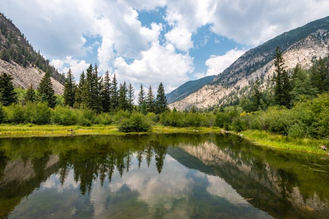
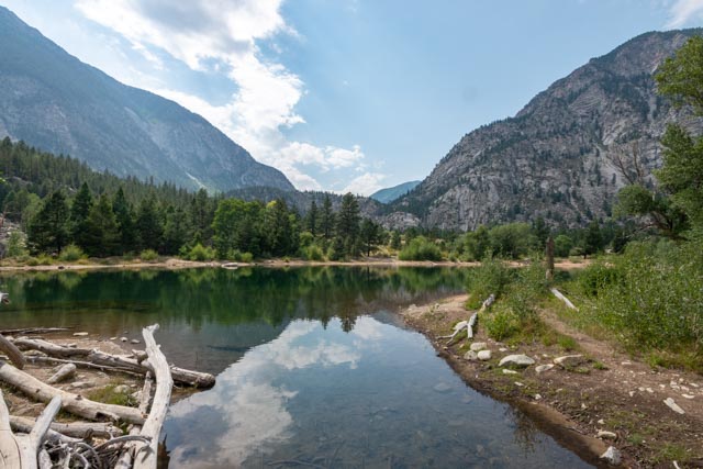
I chose to skip climbing Mount Huron this morning, I am still hurting from Mount Massive. Instead, we made it an easy day. We started with a drive to Nathrop, south of Buena Vista and take the dirt road to Tincup Pass. As we were heading up Chalk Creek Canyon slowly, so we could enjoy the scenery, we spotted this lake through the trees. Literally! We walked through some bushes, across a creek and came to this view. Yes, there were trout in this lake. I walked partially around the lake to get a shot facing south and one facing north.

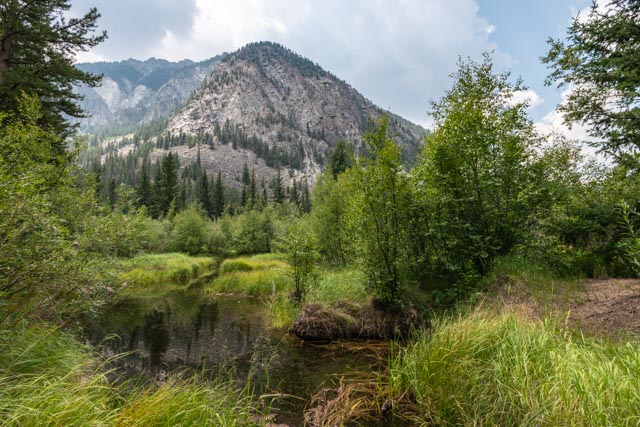
Once we returned to our truck we continued until we spotted this little lake. It was surrounded by berries of some sort and we were in bear country. We made this stop short.
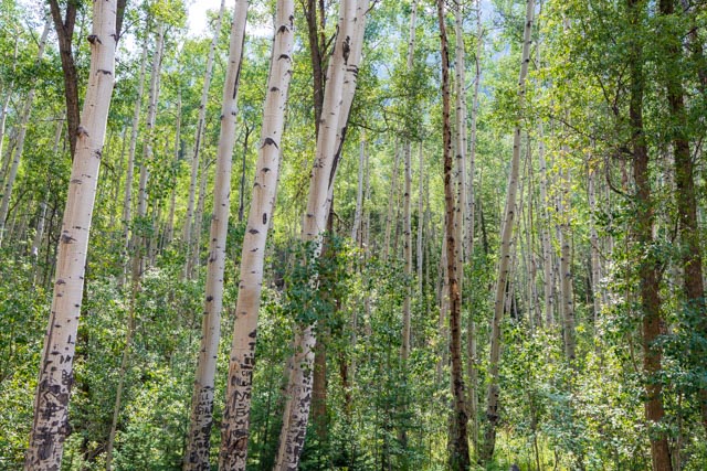
The aspens alongside the road leading up the canyon were stunning.
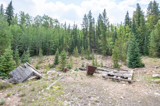
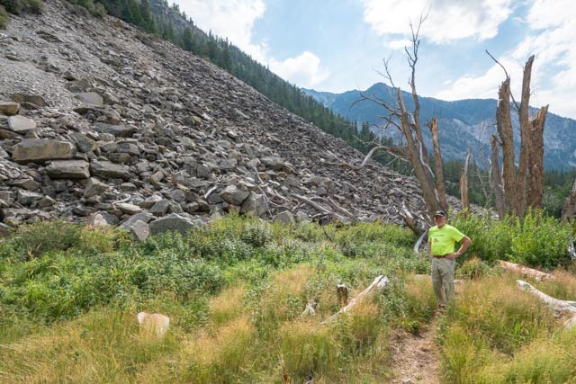
When we started seeing the remnants of mining operations we knew we were close to St. Elmo, our first stop. This is a complete ghost town with over 40 buildings still intact! That is a complete ore cart from the mines. The trucks are laying in the front. If only this would fit in the motor home.
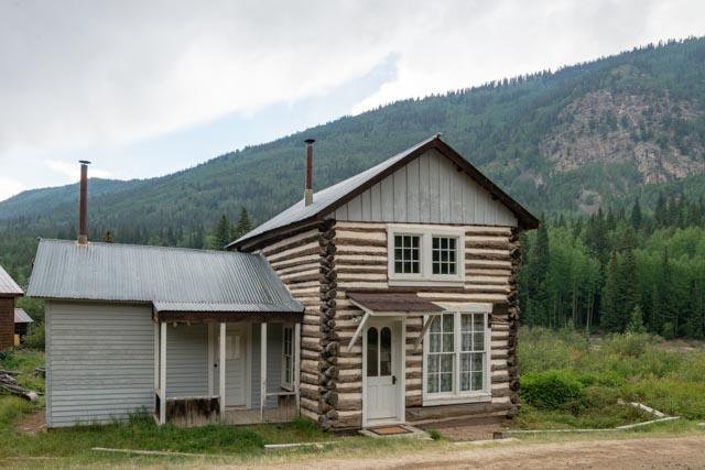
Cathy is standing in front of the Whitney Forbes Maine house, built in 1882.

Is it too early to get a Christmas tree? We had plenty to choose from. I liked the tall, skinny trees in the higher altitudes but would not be willing to carry one down. As you can see, St. Elmo is within the treeline, thus under 11,500 feet in elevation. St. Elmo sits at 10,054 feet.

The main road through the center of town dead-ended at the last building so we continued on a trail down to this creek. The water was crystal clear and loaded with fish. We were surprised there are not more fisherpersons working these creeks and lakes.

Heading back into town from the far end, we stopped to look at the buildings and outbuildings . I am standing in front of the American House Hotel Parlour, built in 1882.
This building was a combination town hall and jail. You can see the cell in the back.
We did find this fixer-upper for sale on the way to the school. I tried to contact the realtor but the only Western Horizons Realty that I could find is based in Mesa, AZ. Maybe I was too late? Oh well, the kitchen was not big enough anyway.


Cathy is standing in the entry to the schoolhouse.

This is the view of the town walking back from the school, which was located across the creek.

The sky was continuing to cloud up and the first thunderclaps sounded the alarm. We made it to the other end of town rather quickly. You don’t want to be caught in a thunderstorm at these altitudes.
We stopped at the general store, the only business still operating in town. After enjoying an ice cream bar, we went across the street to see the chipmunks in a pile of wood.
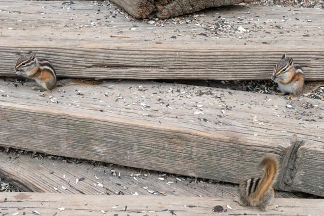
Normally we would not be feeding wildlife but these guys are apparently old pros. The Postmaster was feeding the ancestors of these guys more than 40 years ago and it has been going for chipmunk generations. The first four shots are me and the second four are Cathy.
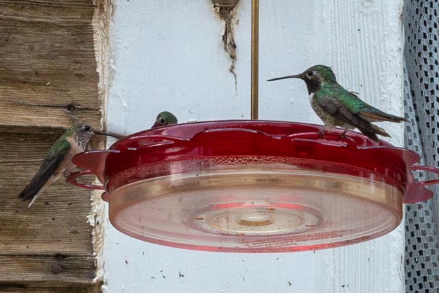
In addition to the chipmunk feeding frenzy, there were dozens of hummingbirds enjoying the several feeders at the front of the store and dozens more at the two feeders we found at the back of the store. The rain started when I decided to buy several strands of barbed wire and Cathy waited by the store while I went the length of town to retrieve our truck.
This was the last building we saw while leaving town in the rain.
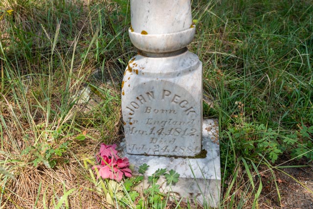
We took the turn, again on a dirt road that deteriorated quickly to a 4 wheel-drive road which went through the town of Alpine. Alpine is not even on the map! We drove out past the private lake then turned around. We did not feel like bouncing down this road for another six miles to reach Tincup. We did go down a dead-end side street in town and came across what I thought was a trail head. We walked down the trail and found ourselves in the old cemetery. This remnant of a headstone confirmed it for me. John Peck was born during the War of 1812 with Great Britain.
Most of the headstones in the cemetery are unreadable as they were made of wood. It is surprising that they have lasted as long as they have in this environment. We saw a deer in the vicinity then a doe and a fawn. It was pretty quiet here, miles from civilization.
Back on the road, heading down the canyon, I spotted this sawtooth ridge. I have been on several of these this trip and they are awesome. We are in the Collegiate Range and Mt. Princeton is nearby.

We stopped at Chalk Lake, which again was crystal clear and the trout were jumping constantly.

Cathy is at the inlet to Chalk Lake. You can see the original roadbed for the Denver, Southpark, and the Pacific Railroad. The railroad never turned a profit and the tracks were removed during WWI.

We walked around this lake and this is the outlet.
On the backside, I saw this trail up the hill and wanted to take it . . NOT! It looked exactly like all of the “easy” trails up the four peaks that I have done this week.
This is a parting shot of the Chalk Cliffs. The pure white cliffs would be brilliant if the sun was out. The creeks leading from this feature are semi-milky with the pure white silt.

We stopped in Buena Vista at a hamburger stand that has been in business since 1955. We passed it several times this week and it was busy, busy, busy each time. We made the right choice, it was darned good.
14’r Count to date:
- Mount Evans 14,264 feet
- Quandary Peak 14,265 feet
- Mount Sherman 14,043 feet
- Mount Massive 14,421 feet

Y’all have given me a great education with the places you have been. Thanks y’all be save out there
Sent from Yahoo Mail for iPhone
LikeLike