We took a drive up to the small town of Idaho Springs. We spotted this town on our return from the Mount Evans climb. The area is studded with mines, very similar to the California Gold Rush area along Highway 49. The town was founded in 1859 when gold was discovered at the confluence of Chicago and Clear Creek. The gold rush that followed attracted over 100,000 miners, known as Fifty-niners.

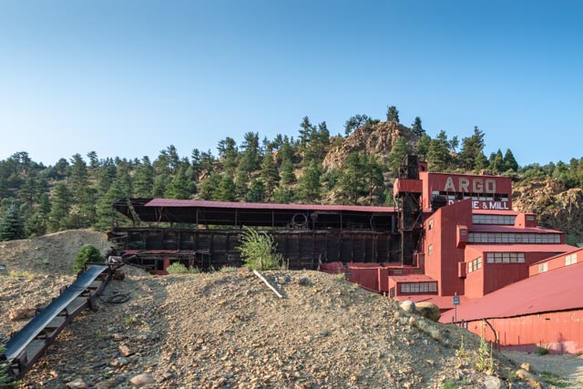
The Argo Gold Mine and Mill is a former mining and milling property consisting of a gold mine and gold mill in Idaho Springs, Colorado, built at the entrance of the Argo Tunnel. The tunnel was built between 1893 and 1910 to drain the gold mines in six mining districts and allow easier ore removal. The mill was built at the entrance of the tunnel to process ore from the many mines drained by the tunnel.
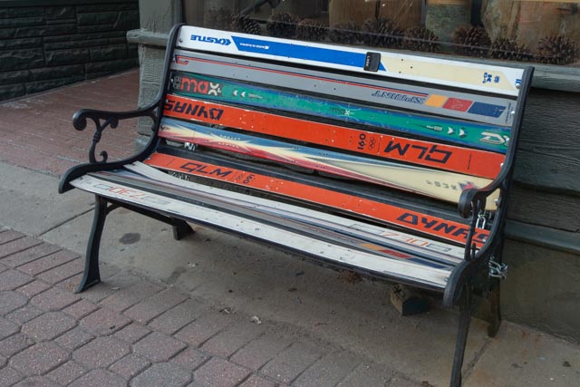
Skiing is very popular in this area, as evidenced by the construction of this bench. We also saw fences which had their boards replaced with used skies!
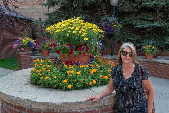
This is Cathy at Citizen’s Park in downtown Idaho Springs. The park was built on the site of the Colorado Bar Building, which burned to the ground in 1989. The next photo is a shot of the downtown. There were a multitude of unique restaurants and bars in this district.

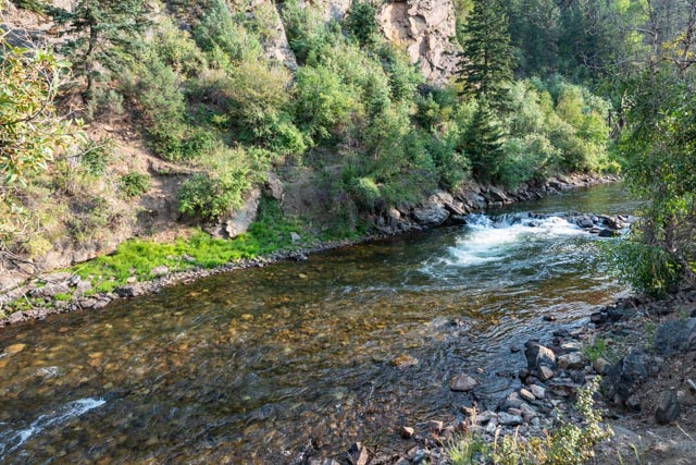
We walked under the Interstate to the Clear Creek and noticed these abandoned mines in the hillside directly across from us.
The creek is loaded with brown trout and is fished quite regularly.
This is the Charlie Tayler Waterwheel, which was used to power a stamp mill on his gold mining operations on Ute Creek.

Leaving Idaho Springs, we went to the grave of Buffalo Bill Cody. This site is high up on Lookout Mountain and the sunset views were gorgeous.

Looking west from Lookout Mountain at the sunset…

This is the view looking east. That is the Coors brewery (the nation’s largest) down in the valley.

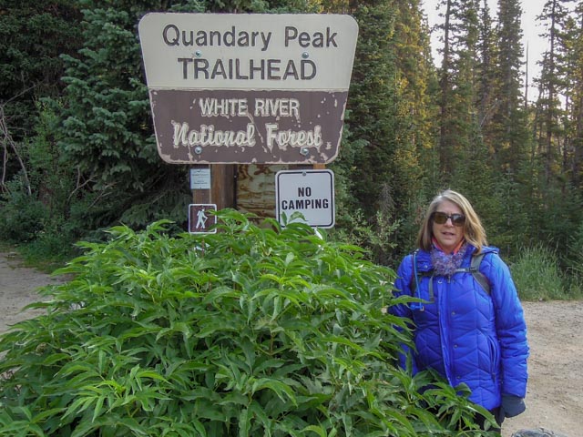
At 7:00 a.m. we started on the East Ride Route up Quandary Peak. Unfortunately, we made it about a half mile up the trail and I had to descend. We weren’t sure if I had locked the car or not. I started this 7.5 mile climb with a mile under my belt!
A couple of views on the way up. I was still below timberline at this point.

Ahh, the road to the top. There are many hikers visible but you cannot see them in this photo. There was still about 2,000 feet vertical and 1.5 mile to the top!
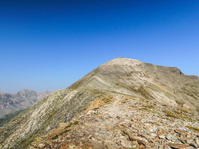
Getting a little higher, the views simply got better. That reservoir below was huge. We later tried to drive there, the road looked paved from the summit, but in reality it was long, dusty and rutted. We turned around at a lake below the resovoir.

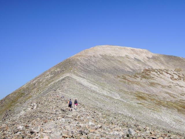
I was getting a little closer the the summit. This is just past the 13,000 foot cairn. The “trail” goes up the knife edge ridge directly in front of these two.
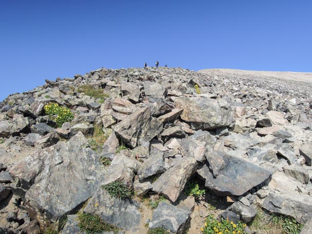
There was a rock scramble for the last mile of the climb. It was difficult going up and even worse coming down. Trails were not readily evident at this point, you just kind of followed the person in front of you, unless he/she stopped, then you were on your own!
I reached the summit at 10:30 a.m. and met a gentleman from Wisconsin. He had carried this banner to the top for his celebratory photo and offered to take a picture with me holding it.

I photographed the official survey marker at the top of the mountain then descended a few feet to enjoy a quick lunch (Cliff Bar, Gatorade and a Bloks), yum yum!
I took a couple of more shots over the edge, looking north and northeast (the sun was on the other side) before starting my descent at 11:00.
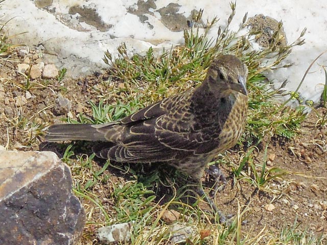
I met this bird on the way down. She was hopping beside me on the trail, and did not appear to be afraid of humans. She posed a couple of feet from me, about as close as I have ever been to a (live) wild bird.
My camera battery went dead just after the bird picture and wouldn’t you know, around the next turn was a baby mountain goat with her mother, right in the middle of the trail. I found out the “hard” way though, as I was descending, keeping an eye on the mama, I missed the kid. I came within a few feet of the kid, chewing grass on the side of the trail (they blend in), startled her and she ran to mama, down the trail. Mama looked up, saw me and her baby running to her and immediately turned towards me. She stopped short when she felt her baby was safe but made it very clear that she would not tolerate anyone messing with her baby! I sat down and waited until more hikers arrived, about 15 minutes, then a buffed macho man appeared and said he would “clear the path”for us! After puffing up and heading towards the mama goat, and the mama goat standing her ground, he decided to let it be. Pretty smart of him. We cut across country, downhill to avoid the pair and continued on. Around the next turn, there they were. They had cut cross country also and were continuing down the same trail. Evidently hikers shed their food on the way up and the goats were feasting. They led us (at a very slow pace btw) for about 1,500 feet vertical. I wound up jogging a little to make up time once we hit treeline, whereas the goats turned back up the hill. I made it back to the trailhead by 1:15 p.m.
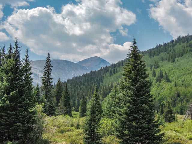
We headed to Breckenridge and stopped to take this parting shot of Quandary Peak through the trees. It is the tallest mountain in the center. It doesn’t look too hard from here!
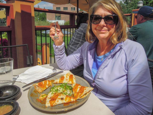
We stopped at Mi Casa restaurant in Breckenridge on the way back for a quick-lunch. Cathy is enjoying her Mango Duck Quesedilla (I had a more original cheese/chorizo). We learned of this restaurant from Jerry Funk’s book “14er Fan Club”. It was his “after climb” destination.
We pulled off the interstate at the Silver Plume terminus of the Georgetown Loop Railroad. They use a three truck Shay locomotive, which is gear driven, quite unusual today. The mountain in the background, behind the railroad cars was a little interesting. The bare rock behind the first car was glacially scrubbed, the streaks on the mountains in the center are avalanche runs, the grey splotches are mine tailings and off to the left, off camera was evidence of a massive landslide. All of this on one smallish mountain with the top is above treeline as well! We followed the railroad line into Georgetown, just a few miles down the interstate.

In Georgetown, we were unsuccessful in locating the bighorn sheep that reside in the mountains there but they are pretty rare in Colorado. The herds were decimated in the early 1900s and are just starting to come back. There are probably less than 100 in the heard that is in this area.

In the morning, I was a bit sore from the previous day’s hike so we took it easy. Our first stop was Dinosaur Ridge, which was about five miles away. This is a mile and a half long protected hillside where evidence of prehistoric life has come to the surface. We opted for the 2+ mile self-guided walk and were amazed how many people actually take a bus tour.
It rained on the entire uphill portion of the hike but warmed up somewhat going back downhill. Yes, we got a little wet and I struggled to keep my camera dry.
Our first stop was at what is known as the Western Interior Seaway. Millions of years ago the sea covered the area from the Pacific to the Denver plateau. These wave ripple marks are evidence of a shallow water environment with a sandy bottom that is influenced by either currents or waves. As the crests of these ripples are indicative of wind direction, there are several wind directions evident in this formation.
Next we came across this large rock surface absolutely loaded with dinosaur tracks. Represented here are:
- Eolombia, an ornithopod, a herbivore with a length of 30 feet and a weight of 1-3 tons
- Acrocanthosaur, a theropod, a carnivore with a length of 22 feet and a weight of 2.5 tons
- Ornithomimid, also a theropod, an omnivore with a length of 12 feet and a weight of 300 pounds
- But studying these tracks, scientists have determined the habits of these creatures (whether they travel in groups, their stride length, and their weight)
Here are claw marks left by a crocodile while crawling his way along the sea floor.
These downward bulges in the layers of sandstone were most likely caused by the back feet of a brontosaurus. The type of brontosaurus was most likely an apatosaurus, which were 90 feet long and weighed about 40 tons. Bones of the apatosaurus have been found in the immediate area.
This is the footprint of a young allosaurus, a theropod. Scientists have determined, through footprint analysis that this particular animal was about 11.5 feet in length. The boulder that this print was on was dislodged by a road crew in 1937.

The following dinosaur bone fragments were found in what was a bend in a prehistoric river. The bones accumulated here and were covered by shifting sand, It was interesting how the larger bones separated from the smaller bones, and helped scientists determine theories of the river, including:
- inside or outside edge of the bend, based on the location of the larger/heavier vs smaller/lighter bone fragments
- the current flow based on bone size and weight
Next, we decided to visit the Mother Cabrini Shrine, with its famous outdoor Stations of the Cross, viewed by climbing 370 steps uphill and 370 steps back down! This shrine is dedicated to America’s first citizen saint, St. Francis Xavier Cabrini. St. Cabrini founded the Order of the Missionary Sisters of the Sacred Heart, and orphanage and numerous other schools and hospitals.
Mother Cabrini loved the mountains of Colorado. The foothills west of Denver held a special attraction for her. During her journeys in 1902 to visit the Italian workers and their families in the Clear Creek, Argentine, and South Park mining districts, Frances X. Cabrini discovered a property on the east slope of Lookout Mountain owned by the town of Golden. No reliable source of water was known to exist on the property at that time, although there were two fine barns and a spring house built in the 1890s. In 1909 -1910, she negotiated the purchase of this property as a summer camp for her charges at the Queen of Heaven Orphanage in Denver, CO. A farming operation, with poultry, other livestock and dairy cows, was established and maintained by three of the Sisters of the Sacred Heart who set up living quarters in the loft of the larger barn. During the summer months, groups of about twenty girls, according to age, would spend several weeks at the summer camp. They enjoyed the freedom of the outdoors and recreational activities in addition to tending the animals and performing farm chores.
The only water was in a small pond next to the spring house. All of the water needed for drinking and cooking had to be brought up to the summer camp from the stream at the bottom of Mt. Vernon Canyon. In September 1912, the sisters complained to Mother Cabrini that they were dying of thirst and there was no water to be had. She answered, “Lift that rock over there and start to dig. You will find water fresh enough to drink and clean enough to wash.” The spring, which is housed in an 8,000 gallon tank, has never stopped running. Many pilgrims, through their faith, believe the water has brought healing and peace to their lives.
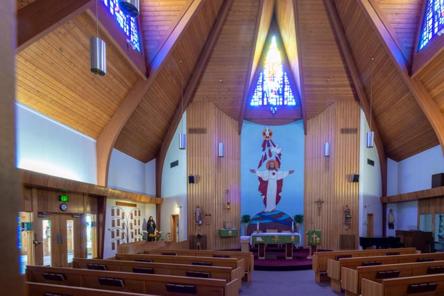
This is the main chapel.
These windows originally came from Villa Cabrini in Burbank, California, which was a school formerly sponsored by the Missionary Sisters.

In 1954 a twenty-two foot statue of the Sacred Heart of Jesus, carved by an Italian artist was mounted on an eleven foot base and erected above the Heart of Stones.

On her last visit to Colorado in 1912, Mother Cabrini took several sisters and a few of the children from the orphanage by horse and buggy along a cow path to the foot of the highest hill. Leaving the buggy at the base, they climbed to the top where they gathered white stones and arranged them on the mountain in the shape of a Heart surmounted by a cross; with the smaller stones, she formed a crown of thorns on the highest promontory, overlooking the city of Denver. Frances X. Cabrini dedicated the hill to the Sacred Heart of Jesus, naming it the “Mount of the Sacred Heart”. Cathy is enjoying the still present stones there beneath this glass case.

Cathy is taking a drink of the water emanating from the original well at the shrine.

14’r Count to date:
- Mount Evans 14,264 ft
- Quandry Peak 14,265 ft

Beautiful place
Sent from Yahoo Mail for iPhone
LikeLike