After crossing over from the coast on Highway 299 through Weaverville, we stopped in Burney to spend some time at their street fair. Our first choice was Highway 36 into Red Bluff, but it was closed for repairs/construction and we noticed a sign warning it was not suitable for anything over 30 feet! Highway 299 was a good road but very steep in areas. We passed an overturned tanker truck on the way up who evidently lost its brakes and slammed into the mountain. You could not recognize the type of tractor due to the damage. We passed a travel trailer that had come unhitched from its truck on the way down. The travel trailer had smashed into the opposing guard rail before coming to a stop. Whiskeytown Lake was full and beautiful, Weaverville is still a neat old town with a Buddest Temple and we decided to fuel up before continuing into Lassen. We had to disconnect our truck to make the turns into the fuel stop, but we are pretty fast doing that now! After fueling, we continued on to our camp, between Hat Creek and Old Station.

I inquired about a fish hatchery on Hat Creek and was given directions by a local. We could not find the cross street she mentioned so we plugged it into our Garmin. It took us down a dirt road, up into a canyon, through “No Trespassing” signage, barbed wire and continually worsened. The dust was several inches deep in the ruts (more of a trail than a road) and all we saw were range cattle. It was getting dark and Cathy said “Stop!” There was a cable stretched between two trees that I did not see. I think we may have stopped suddenly if Cathy hadn’t seen it. We turned around and made our way back to the highway, somewhat quicker and a whole bunch dustier. We traveled a mile or so further down the highway and immediately found the correct road to the hatchery. I must have more patience. We arrived at Hat Creek and Jason befriended a couple of local fishermen. One of them hooked a rainbow and gave his rod to Jason, who “reeled” it in. It was a 18-20 incher and probably weighed about 4 lbs. Hat Creek is the number one trout creek in the state. They had limited out (5) and were simply doing the “catch and release” program. They also mentioned making trout stew, which sounded good to Cathy.
This is the tailgate of our truck with the dust. We made a trip into Burney for a car wash.

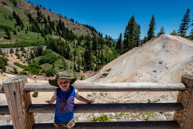
In the morning we took a ride into the park to see “Bumpass Hell” but it was closed for trail construction when we arrived. It will not reopen until 2019. This is the most remarkable volcanic feature in the park and named after a man named Bumpass who fell though the surface and severely burned his leg in the sub-surface boiling water. Oh well. After turning around at the Southwest Entrance station, we stopped at this roadside set of mud pots, known as the Sulphur Works. Jason enjoyed the bubbling mud that sometime went several feet into the air!

It was getting warm near midday so we stopped at Emerald Lake. I convinced Jason to try the water. It was pretty cold but crystal clear.


He would not go in past his waist so we packed up and continued on to Lake Helen. This lake was originally called Sapphire Lake but renamed after the first woman to climb Mt. Lassen in the early 20th century.

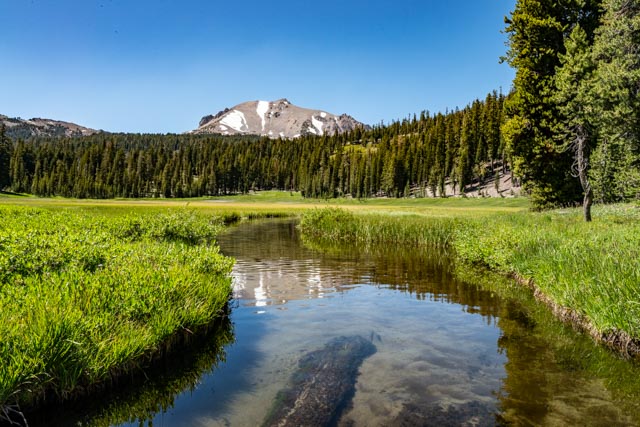
We stopped at the trailhead for Mt. Lassen to get some trail information (snow, condition, elevation change, etc. for our climb the next morning) and made a stop at Upper Meadow. King Creek flows through this large meadow and, with Mt. Lassen as a backdrop, made a pretty good scene. I got into the water and took this shot. There are three rainbow trout at the end of the submerged log and several more were in the stream behind me.
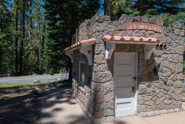
We stopped at the B.F. Museum and Bookstore at the North Entrance station and took a look at this seismograph, that was installed early in the 20th century to monitor the area for future activity (It has since been replaced by satellite monitoring). This volcano erupted in 1914 with a devastating impact. Mt. Lassen is one of the largest plug volcanos in the world and the park is unique in that all four types of volcanos can be found within its borders.
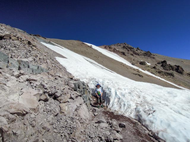
We left early in the morning, to beat the heat in our attempt to climb Mt. Lassen. There was snow at the trailhead but we were told there was very little at the top, as it had direct southern exposure.
We took a shot of this feature, a plugged vent in the rock and Snag Lake (I think) in the distance.


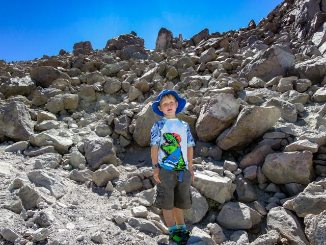
We did find some snow on the way up but the trail crew had cut a bit out so we did not have to get on it. We climbed a five foot wall to bypass this area, though.
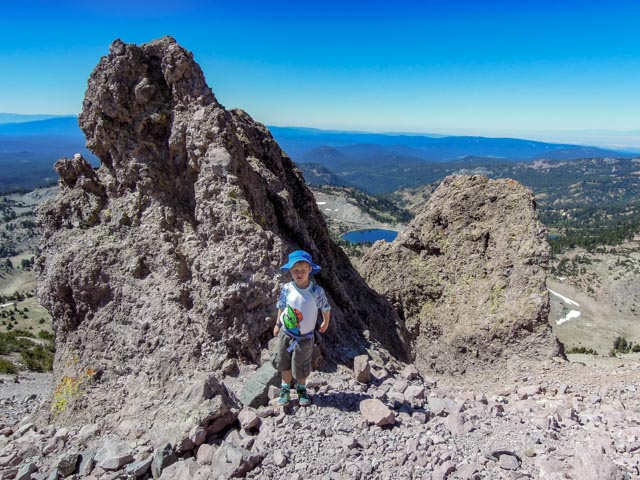
Jason stopped for this shot about two-thirds of the way to the top. You can see Lake Helen over his shoulder.
We reached the “top” and I explained to Jason what a “false summit” is. We had to cross this snowfield (about 200 yards) and continue to the real top, a 200 yard scramble over loose rock. There were only four of us on the actual summit, most rested at the false summit, not willing to make the effort to actually reach the top.

We had lunch on top, Jason found a comfortable rock to plant himself on and we noticed, about halfway through our lunch that we were on the actual summit marker! This is Jason’s first mountain over 10,000 feet. Most climbers told us they had never seen one so young make it all the way!
This is what is left of the actual crater of Mt. Lassen after the most recent eruption.

A couple of shots taken on the decent back to the trailhead.
We joined a group of Boy Scouts from Red Bluff for a Ranger-led discussion on local bears. It was a lively (and well-behaved) group. Jason got one of his “Junior Ranger” projects signed off by the ranger.

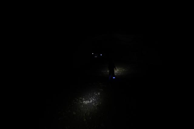
After a hot climb up the mountain, we stopped at Subway Caves, a State Park, located just outside of the National Park. I brough headlamps for Cathy and Jason and I took my Surefire. It got dark quickly once we entered the gigantic lava tubes.

My flashlight, following Jason (he had running lights on his feet) and Cathy is just in front. This is with the illumination of three, 200 lumen lights!
Jason spotted the two mini volcanos that were found within the tubes. Cathy is reading one of the informational postings, located within the tubes.
This is an exit back to the surface. The cave we were in was about 1,300 feet in length and completely dark, and oh yes, very cool at about 55 degrees!

