After finishing the Yellowstone Half Marathon, we decided to take one last trip in the park to try to get parking near the Lower Geyser Basin (Fountain Paint Pot) and the Midway Geyser Basin, home of the Grand Prismatic Spring. We waited patiently and within a few minutes were cued up for a parking space. We managed to get a few glimpses of sunshine during our visit and we took some shots of some of the features.
In Lower Geyser basin, we walked and viewed Celestine Pool; notice the very deep blue, this pool was very hot and deep. The orange algae at the upper end flowed downhill and under the walkway. It was pretty bright when the sun came out.

Leather Pool – This pool was an unusual shade of clear green. It was simply amazing the difference in colors found in pools that were side by side.

Spasma Geyser – This was a geyser-field with smallish geysers spouting up all over the area. Some would be very close to the walkway.
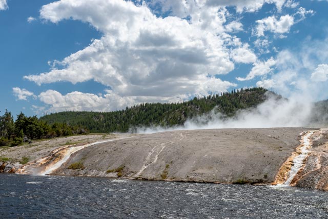
When we finished the walk through the myriad of geysers, pools, and springs, we continued down the road towards Old Faithful to Midway Geyser Basin, specifically to view the Grand Prismatic Spring. I started to walk parallel to the river to get a good shot of the runoff from these geysers into the Firehole River but there was signage posted to keep on the established walkways as they were attempting to reinvigorate the vegetation on the riverbank. We did not leave the walkways but watched as hundreds simply ignored the multiple signs and trampled the area to walk out to take photographs. Below you can see the water from the Grand prismatic Spring entering the Firehole River (taken from the established walkway).
Opal Pool – This large, hot pool sported a vivid turquoise color.

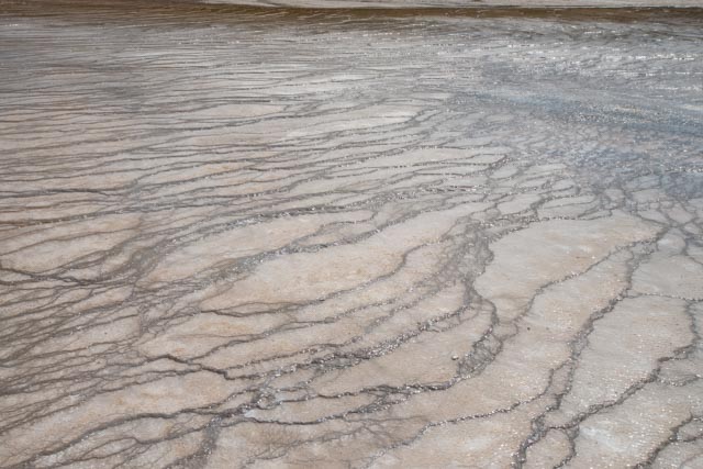
Patterns in water leaving one of the pools were sometimes remarkable. These lines separate the minute levels of water cascading out of a pool.
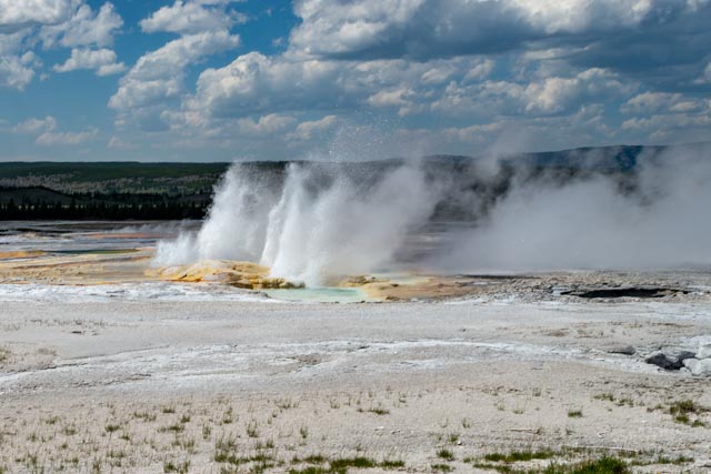
Grand Prismatic Spring – This is the “mack daddy” of springs in the park. The size, the color(s) and the runoff directly into the river; this guy had it all. We had to wait for a few minutes to let the sun out of the clouds for a “sunshine shot”.

Excelsior Geyser Crater – Jason like this crater because there were several hats in and near the water. It was very windy in this area and hats were blowing off heads. Jason had Cathy carry his hat, he caught on rather quickly.

We left West Yellowstone traveling north on Highway 191, the principal route for most travelers, but quickly left this road for a less traveled route, Highway 287 This took us through the Madison River Canyon/Earthquake Lake area, then turning onto an even less traveled road to Virginia City, Nevada City, Sheridan, and Twin Bridges.
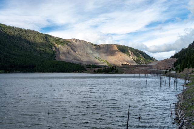
On August 17, 1959, this was the site of the Rock Creek Campground, which was full of campers and fishermen. At 11:37 PM a massive earthquake rocked the area, causing 80 million tons of rock and debris to smash through their campsites. Upstream, hurricane force winds (caused by the massive land shift) created a wall of water that swept away vehicles, tents, and people. More than 200 people were rescued from the debris fields, but 28k persons lost their lives here, with 19 still entombed in the debris, never to be recovered. The morning sunlight is highlighting the great slide and the lake that was created as a result.
Earthquake Lake:
Continuing on 287 we turned off the road onto an even less traveled highway at Ennis, which led us through Virginia City, Nevada City, Sheridan and Twin Bridges before turning again onto Highway 2 leading us to the interstate.
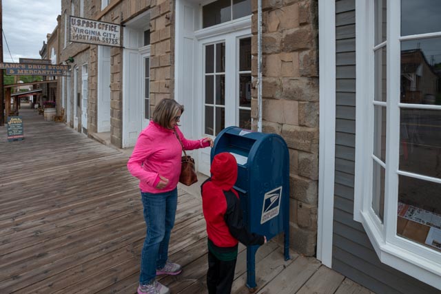
Virginia City was an unexpected stop. The townsite had been restored/kept in it original condition and we were early and almost alone. We stopped for a quick breakfast but had to walk the town, as each storefront was open and the interiors were stocked with supplies, equipment etc., to make it appear just like it was. This was eerily similar to the Ghost Town of Bodie in the California desert.
Jason decided to mail a postcard from the Virginia City Post Office. We had to convince him that the PO was real and operational. He believed it was old and just a prop.
This framed mounting, including 94 different barbed wire examples dating from 1867-1909 was above our table and the diner that we stopped at. Not many can see the significance in this but I used to collect examples on my sojourns into the foothills of California, seeking glass telegraph insulators and antique bottles, there are some super rare examples here. This is the largest single collection I have ever seen.

Cathy and Jason stopped in front of a wagon that need some repairs. It has probably been sitting here for many years. Some of the wood was just rotted through. Other than that it was pretty complete!

Continuing back to our MH, down the other side of the street. Almost all of these stores were open and furnished. There was some retail, but not overwhelming.


Jason is checking some of the buildings out back. He had to check to see if that is really a two-holer!

Examples of the interiors of several of the storefronts. This is just a small sampling, there were many more that were open.
After we left Virginia City, we came to another similar, small town called Nevada City. They appeared to be connected by a xx scale (don’t really know the scale but it was less than full size) narrow gauge railway. We did see a RR station in each town and watched the “train” depart from Virginia City, then spotted it along the rails between VC and Nevada City.
We stopped at this city park in the town of Twin Bridges. This was a neat building but there was not a lot of information available. It appears, from the doors and the bars on the windows to have been a holding facility of some kind. A lot of gold and silver traveled from the towns along the river and robberies were a common occurrence in this area. One of the markers we read here was that the entire sheriff department was in on the robberies, which suddenly stopped when the townsfolk got angry and hung about 20 of the sheriff and deputys. Coincidence?

Jason could not find rocks to throw, so he went to a backup plan of sticks and cones.

The Miners Monument, located near Kellogg, Idaho, was built to honor the victims of the Sunshine Mine disaster in 1972. There were 178 miners in the Sunshine Mine, working at various levels when fire broke out on May 2, 1972. Carbon monoxide, heat, smoke and gas spread quickly through the tunnels, severely hampering rescue efforts. 85 workers made it to safety, two more were rescued alive seven days later and the last of the 91 victims were brought to the surface on May 13th. The Sunshine mine is the largest hard rock mine in the nation, over one mile deep and more than 100 miles of tunnels. This was the country’s worst hard rock disaster since 1917.

We stopped in Spokane at Costco to resupply and left the parking lot with one of our basement doors wide open. Luckily we were alerted by several motorists and were able to close the door without loss.
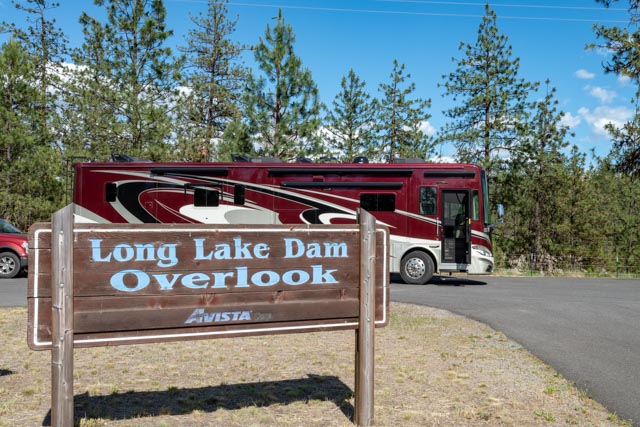
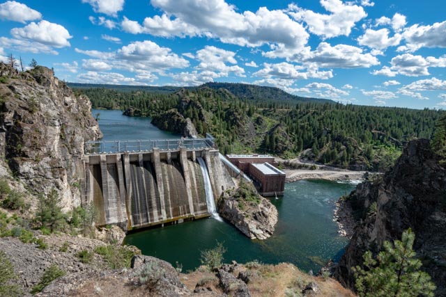
In Spokane, we headed north to Tum Tum in search of the Indian Rock Paintings. We did not find them but continued on less traveled roads to Grand Coulee. We did stop at this viewpoint and stretch our legs and let Jason romp.
There was a short hike down to the viewpoint, passing an eagle’s nest along the way. Again, we were alone at this stop.
Jason, the mountain goat, is trying to scale the rocks rather than use the stairs. You can see the eagle’s nest above him in this photo.

After some goading by the bird, I decided to go and get my “big lens” to see if I could improve. These shots were taken from the same distance as the previous picture.
