We left Skagway in the morning, after the Post Office opened. Taking the only way out, the South Klondike Highway, we passed the avalanche gates as we left town, then made the steep, 14-mile, 3,300 vertical foot climb up to the White Pass Summit. The US Customs station waved us through, but the Canadian customs station was several miles further up the road. We were unexpectedly held up at Canadian Customs until almost 1400, long story . . . but we finally got cleared to pass. They (two agents) went through our coach with a “fine tooth comb”, even pulling out remote camera equipment to view areas where we didn’t know we had areas. They were “alerted” by some apparent modifications to our console in the truck. They took me aside and questioned me at length as to what I knew about the pry marks and loose screws. I really didn’t have an answer, but a couple of hundred miles later realized they removed our console to install the tow package, including wiring and air lines for our brakes. Oh well..
We refueled at Carcross then took the Taglish bypass, paralleling Marsh Lake for about 20 miles back to the Alcan. The lakes in the Yukon are loaded with lake trout, burbot, rainbow trout, whitefish and northern pike. We seldom saw anyone fishing. I talked with a Carcross native while fueling and he told me that yes, they do get very crowded during the season. In late June and early July you might see up to 25 boat trailers parked near the ramp and you may pass a boat every twenty minutes or so on the lake. The lake is 115 miles long, cold and crystal blue. This is a different description of “busy” that I am used to. We fueled again at Watson Lake; it was still open and was probably the last fuel/civilization/anything for miles.
We were both checking for the Aurora as it was a relatively clear night with the Aurora forecast from the University of Alaska predicting a “4”. (This was a neat app we added to our phones). I was watching the rearview mirrors and cameras and Cathy was looking out the front, in retrospect, probably not the best plan. I had to hit the skids at about 65 mph to avoid a momma moose and her moosette who were standing in the roadway in total darkness. Possibly a result of spending too much time watching the rear view mirrors?
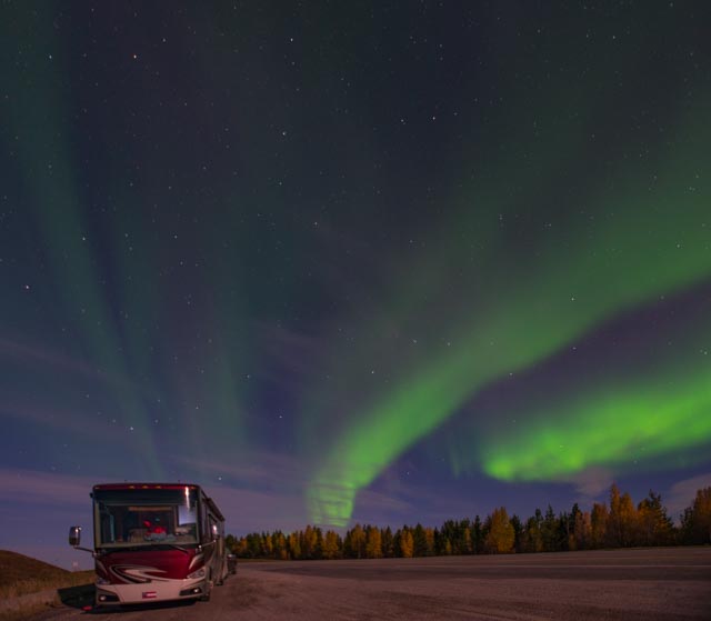
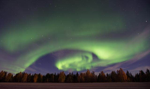
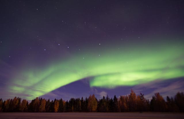
Cathy saw the lights first and we enjoyed them as we continued to drive for miles. As they grew more intense, we pulled over to photograph them. We stayed alongside the road for over an hour with absolute solitude until they started to fade. Here are some of the shots we captured:


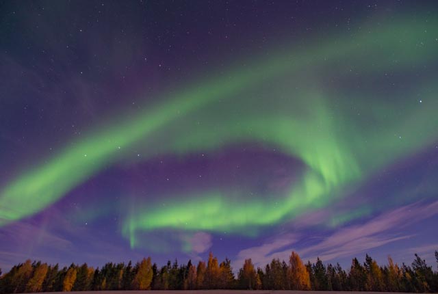

Notice the Big Dipper in this one . . the official symbol for Alaska.
We then continued on for about 450 miles (total for the shortened day) to somewhere near Coal River (it was too dark and we were too tired to really tell where we were when we pulled over at midnight). The snowshoe hares were out in numbers along the road and we saw several foxes (probably having rabbit for dinner).
We awoke fairly early and set off for Ft. Nelson. In a couple of miles, we saw hundreds of bison in multiple herds in the roadway. Once we cleared most of the bison, we hit road construction. It took about half an hour to wait for the pilot car then we travelled about 20 miles at 15 mph until we hit pavement again. The pilot driver was not happy with my slow speed but it was not his paint. Oh well. We finally reached Ft. Nelson and because we still had daylight left, decided to make the 200-mile side trip, on the Liard Trail of the Del Cho Route to Ft. Laird. On the way to Ft. Liard we passed several herds of bison on the roadway but saw little, if any evidence of human habitation. Ft. Laird is located in the Northwest Territories.

About 40 miles down the Laird Trail; we traversed over the Ft. Nelson River via the Bailey bridge. Unbeknownst to us, this bridge is the longest Acrow Bridge in the world at 1410 feet with a span of 230 feet pier to pier. Named after designer Sir Donald Bailey, it is designed of interchangeable steel panels coupled with pins for rapid construction. We are glad we made the side trip as the bridge is currently being replaced with a new span at a cost of $35 million. The old, wood decked bridge is closest, on the steel pilings while the new structure is on the concrete piers to the left.


